


Temblor

Temblor介绍
A PERSONAL SOLUTION TO A GLOBAL PROBLEM
Half of the world’s population lives near active faults, and so could suffer earthquake damage. Most do not know they are at risk; many of the rest do too little, too late.
Temblor enables everyone in the conterminous United States, and eventually the world, to learn their seismic hazard, to determine what most ensures their safety, and to decide what best reduces their risk.
Temblor works anywhere in the United States, using the best available public data and methods. Our goal is to make earthquake risk ‘real,’ without scaring, soothing, or snowing people. Navigating through Temblor, is quick, fun, and easy. Info buttons explain its calculations, estimates, and data sources.
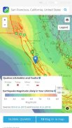
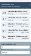
In Temblor’s map you can see the faults and recent quakes around you; use your current location or enter an address. Temblor typically shows magnitude-1.0 or larger quakes in the U.S, and magnitude-4.5 or larger in the rest of the world; the quakes are updated every few minutes. You can click on any quake for more information. Everything is identified in map legends.
The Temblor Seismic Hazard Rank slider lets you know how your location compares to the most and least hazardous sites in the coterminous U.S. By moving the pin around, you can see how your hazard changes, and how it compares to other areas in your commute zone or nearby.
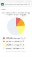
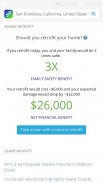
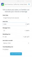
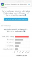
By entering your home’s age and size, Temblor estimates the chances of seismic damage and the cost of repairs in an intuitive, interactive pie chart. Temblor also estimates the cost, and financial and safety benefits of a bolt-and-brace retrofit to your home, so you can assess if this makes sense for you. In addition, Temblor estimates the chances of a payout for a typical earthquake insurance policy for your home at your location.
In an interactive bar chart, Temblor also puts your seismic risk in context. The chart compares your chance of extensive earthquake damage to other perils that most people protect themselves from or insure against, such as a your home burning down or your car being totaled.
In Temblor’s layers menu, you can add liquefaction zones (which can cause a home to sink or tilt when shaken), and landslides (which can cause a home to slide downhill during a quake, or be covered in debris). You can also use a relief map, route map, or satellite image as a base, and zoom in as close as you wish.
Temblor is free and ad-free. Please share Temblor with your friends and family to help our mission to live stronger together.
为个人解决一个全球性的问题
世界一半人口居住的活动断层附近,因此可能遭受地震破坏。大多数人不知道他们有危险;许多其他的做的太少,太晚了。
地震发生在启用了美国本土每一个人,并最终走向世界,学习他们的地震灾害,以确定哪些最确保他们的安全,并决定什么最好降低了他们的风险。
地震发生在任何地方工作在美国,使用最好的可用的公共数据和方法。我们的目标是使地震风险'真正的'无吓着,舒缓,或下雪的人。通过这次地震导航,快,乐趣和容易。信息按钮,解释其计算,估计和数据源。
在地震发生的地图,你可以看到你周围的断层和地震最近的;使用您的当前位置或输入地址。地震发生通常显示幅度-1.0或在U.S较大的地震,和幅度-4.5或在世界的其他部分大;该地震是每隔几分钟更新一次。您可以点击任何地震的更多信息。一切都在地图图例标识。
这场地震地震危险性等级滑杆可以让你知道你的位置,比较在毗连美国最多和最少的有害场所通过移动针,你可以看到你的危险变化,以及如何比较其他地区通勤区或附近。
通过输入你家的年龄和大小,这场地震估计地震损伤和修复的直观,互动的饼图中的成本的机会。这场地震还估计成本,螺栓和撑改造到您的家庭财务和安全效益,因此,如果这是有道理的,你就可以评估。此外,这场地震估计在当前位置典型的地震保险为您的家庭支付的机会。
在交互式条形图,这场地震也使您的地震风险在上下文中。表比较你的其他危险,大多数人保护自己或投保,比如你的家烧毁或被总额为您的爱车广泛的地震破坏的机会。
在地震发生的图层菜单,你可以添加液化区(这可能会导致一个家庭下沉或者震动时倾斜),和山体滑坡(这可能会导致一个家庭对地震中滑落,或碎片覆盖)。你也可以使用一个地形图,路线图,或为基地的卫星图像,并放大亲如你所愿。
这场地震是免费的,无广告。请分享您的朋友和家人这场地震,以帮助我们的使命,住更强在一起。


